
1.
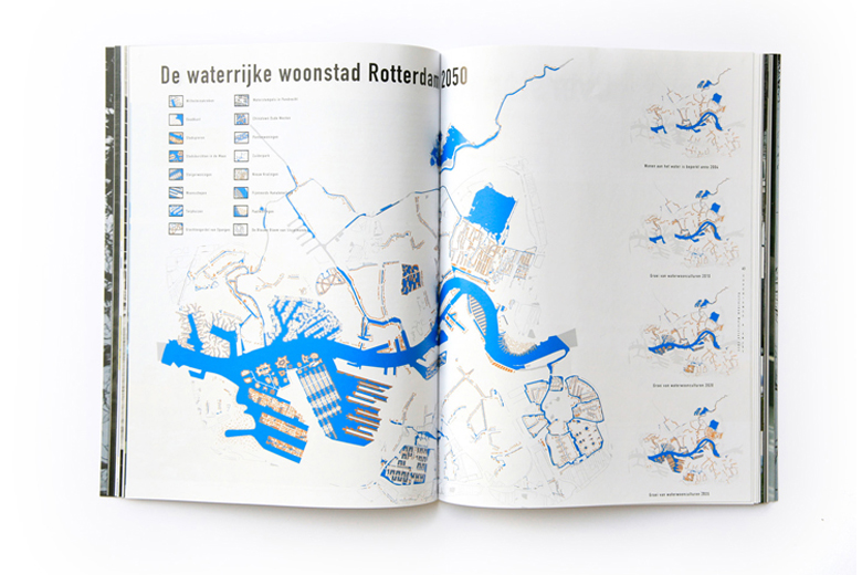
Una delle prime città a pianificare per l’acqua, a partire dal 2001, è Rotterdam che nel 2005 dedicata a questo tema la sua seconda Biennale di Architettura, presentando una visione per Rotterdam 2035 che si svilupperà successivamente (2007) nella Rotterdam Climate Initiative e Rotterdam Climate Proof…
Rotterdam-climate initiative 2007

In 2005 the 2nd IABR, the International Architecture Biennale Rotterdam, The Flood focused on the relation between water and urban design in the Netherlands and around the world, and was a rallying cry to face up to the challenges presented by the ramifications of climate change. The curator of the second edition was Adriaan Geuze, landscape architect and director of West 8.
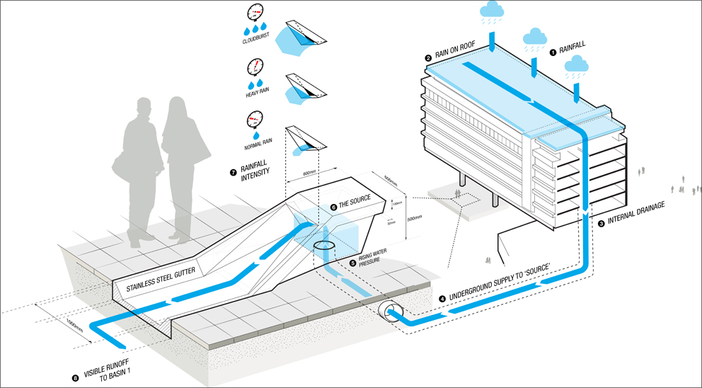
Benthemplein Water Square designed by DE URBANISTEN in 2011 completed in 2013
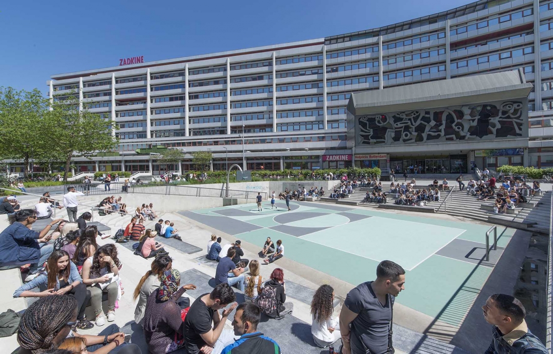
A water square retains water during peak rainfall, easing the stress on sewage systems and preventing floods in highly urbanised areas. A water square retains rainwater as it falls on the square itself and serves as a repository for rainwater falling on the roofs of surrounding buildings. A water square also doubles as an urban public space – the lowered areas designed to retain water can be repurposed for sports and recreational use during dry weather. The Benthemplein, for example, offers room for basketball, skateboarding and performance arts within pits that can also hold up to 1.7 million litres of water during rainfall. The water is infiltrated into the soil beneath the pavement or pumped out to canals elsewhere in the city.


2.
NEW ORLEANS and Hurricane Katrina
In the morning on August 29, 2005, Hurricane Katrina struck the Gulf Coast of the United States.
New Orleans was at particular risk. Though about half the city actually lies above sea level, its average elevation is about six feet below sea level–and it is completely surrounded by water. Over the course of the 20th century, the Army Corps of Engineers had built a system of levees and seawalls to keep the city from flooding. The levees along the Mississippi River were strong and sturdy, but the ones built to hold back Lake Pontchartrain, Lake Borgne and the waterlogged swamps and marshes to the city’s east and west were much less reliable. Neighborhoods that sat below sea level, many of which housed the city’s poorest and most vulnerable people, were at great risk of flooding.
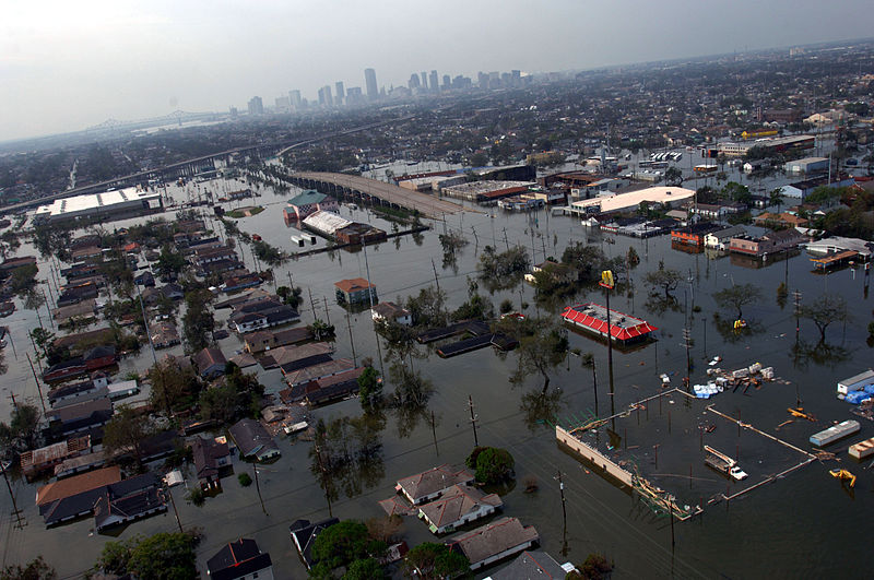
When the storm arrived, it overwhelmed many of the city’s unstable levees and drainage canals. Water seeped through the soil underneath some levees and swept others away altogether. Eventually, nearly 80 percent of the city was under some quantity of water.
Hundreds of thousands of people in Louisiana, Mississippi and Alabama were displaced from their homes, and experts estimate that Katrina caused more than $100 billion in damage.
3.
Grand Paris: La métropole de l’après Kyoto
In 2007 the former French President Nicolas Sarkozy launched an initiative for “a new global plan for the Paris metropolitan region”: The Métropole du Grand Paris. The project was organized by the French state, with the Minister of Culture and Communication charged with coordinating the consultation process.
In 2008 an international urban and architectural competition for the future development of metropolitan Paris was launched. Ten teams gathering architects, urban planners, geographers, landscape architects will offer their vision for building a Paris metropolis of the 21st century in the post-Kyoto era and make a prospective diagnosis for Paris and its suburbs that will define future developments in Greater Paris for the next 40 years.
The architects leading the ten multi-disciplinary teams were: Jean Nouvel, Christian de Portzamparc, Antoine Grumbach, Roland Castro, Yves Lion, Djamel Klouche, Richard Rogers, Bernardo Secchi & Paola Vigano, Finn Geipel & Giulia Andi, and Winy Maas.
Il progetto di città porosa, di Bernardo Secchi e Paola Viganò, propone di valorizzare le stratificazioni dei diversi periodi storici e delle diverse culture degli abitanti della città turistica intra-muros e delle banlieue dando spazio all’acqua e agli scambi biotici. Nonostante l’acqua a Parigi sia importante, l’effettiva capacità della rete idrica non è valorizzata così come non lo sono i rischi di un suo possibile aumento a causa dei cambiamenti climatici. Per questo si ipotizzano delle piattaforme servite da ferrovie e da canali. Luoghi di nuova relazione con lo spazio fluviale che diventeranno di riqualificazione per i fabbricati fluviali. La porosità è allo stesso tempo misura della percentuale di spazi aperti in relazione agli spazi costruiti…

4.
A partire dal 2007 il Royal Institute of British Architects comincia a lavorare sui rischi legati ai cambiamenti climatici, producendo una serie di ricerche proprio sul rischio allagamento…
Building Futures aims to address the big picture. How and where will we be living in 50 or 100 years’ time, when the climate has changed and cities are bigger than ever? What technologies will architects be using to design buildings and what new materials will they be specifying? How will the inevitable new technologies affect the buildings we all use every day?
In July 2009, Building Futures and the Institution of Civil Engineers hosted a design charrette, bringing together a number of professionals from various relevant sectors. We had a select group of top architects, civil engineers, city designers, planners, developers, policy-makers, ecologists and futurologists. The brief was to produce both architectural and infrastructural responses to rising sea-levels on two case study cities; addressing the issue with our three proposed future scenarios – Retreat? Defend? Attack?
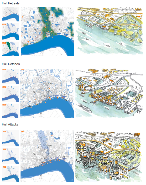
Changing sea levels is not a new phenomenon. In the Netherlands, for example, with 40% of its surface under sea level, water management and water defense have been practiced since time immemorial. The Dutch created mounds and dykes, windmills, canals with locks and sluices, the Delta Works and the Afsluitdijk, all to keep the water out. Now there is a growing realisation that living with water is a viable and sustainable solution: letting it in! So water management changed with a movement towards floating cities, seawater inlets, freshwater basins combined with nature reserves.

Facing_Up_To_Rising_Sea_Levels_RIBA
5.
In 2009 Copenhagen started to work on the COPENHAGEN CLIMATE ADAPTATION PLAN, approved in 2011
https://player.vimeo.com/video/69160394

6.
In 2012 New York was severely affected by Hurricane Sandy
Sandy’s impacts included the flooding of the New York City Subway system, many suburban communities, and all road tunnels entering Manhattan except the Lincoln Tunnel, and the closure of the New York Stock Exchange for two consecutive days. Numerous homes and businesses were destroyed by fire, including over 100 homes in Breezy Point, Queens. Large parts of the city and surrounding areas lost electricity for several days, and several thousand people in midtown Manhattan were evacuated for six days due to the crane collapse at One57. Bellevue Hospital Center and a few other large hospitals were closed and evacuated. At least 53 people died in New York as a result of the storm. Thousands of homes and an estimated 250,000 vehicles were destroyed during the storm. Economic losses across New York were estimated to be at least $18 billion.
The Hurricane Sandy Task Force and HUD (U.S. Department of Housing and Urban Development) launched the REBUILD BY DESIGN competition in June 2013, a multi-stage planning and design competition to promote resilience in the Sandy-affected region.

Ten interdisciplinary teams of scientists, engineers, designers, and architects spent months understanding the major vulnerabilities of the Sandy-affected region and developing projects to improve the region’s resilience. In June 2014, then-HUD Secretary Shaun Donovan announced the award of $930M to seven winning ideas. Each winning idea comprises multiple phases, which collectively represent a master plan for the area of focus. The awards dedicated to the winning designs are provided by HUD to assist in the implementation of the first phase of each master plan.
Winning design solutions will be implemented using CDBG-DR funding as well as other public and private-sector funding sources.
Looking at Winning Proposals…
Bjarke Ingels Group
The Big U is a protective system around Manhattan, driven by the needs and concerns of its communities. Stretching from West 57th street south to The Battery and up to East 42th street, the Big U protects 10 continuous miles of low-lying geography that comprise an incredibly dense, vibrant, and vulnerable urban area. The proposed system not only shields the city against floods and stormwater; it provides social and environmental benefits to the community, and an …
The Dry Line: video by Squint Opera
https://player.vimeo.com/video/117303273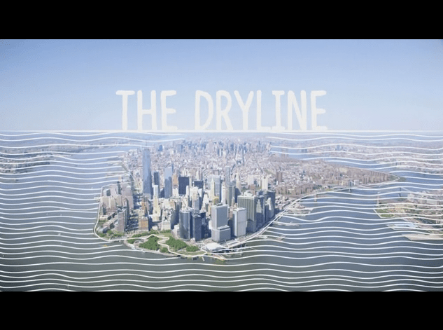
OMA
Resist, Delay, Store, Discharge: A Comprehensive Strategy for Hoboken
Our comprehensive urban water strategy deploys programmed hard infrastructure and soft landscape for coastal defense (resist); policy recommendations, guidelines, and urban infrastructure to slow rainwater runoff (delay); a circuit of interconnected green infrastructure to store and direct excess rainwater (store); and water pumps and alternative routes to support drainage (discharge).
https://player.vimeo.com/video/90759469
…
In this blog:
Blue-Green Infrastructures
The Planetary Boundaries
